Kefalovrysos Cave
Karst source of Ancient Inachos river
Max Depth: 30m | Average Temperature: 11°C
At the foot of Mount Lyrkeio and at an altitude of 770 meters, in a landscape of unique natural beauty with lush vegetation, the settlement of Kefalovrysso emerges.
The mountain village, which emerges under the shadow of the top of Frangokoukouras with an altitude of 1647 meters, belongs to Argolida’s Prefecture and is located 48km. NW of Nafplio.
What makes the village so important is its springs and precisely the source of the ancient Inachos river. The Assumption of the Virgin Mary emerges in the central square of the settlement through a remarkable cave, right next to the main church and cemetery.
The Inachos is the most massive river in Argolida’s prefecture with a length of 37 km that originates through Mount Lyrkeio and flows into the Argolic gulf and Nea Kio.
Greek mythology is rich around this river deity. Inachos is considered the ancestor of the royal dynasty of Inahids. The latter first established the kingdom in Argos and begins the mythological tradition and the ancient historical route of Inachia land, as was the place’s original name and the whole Peloponnese.
According to ancient historians, Inachos established his kingdom on Argos many generations before the flood of Deucalion.
An older flood that occurred in his years flooded the Argolic plain, turning it into a vast lake, as its waters joined those of the neighboring Argolic gulf. Larissa, the last citadel of Argos, the giant rock that rose to the south (Palamidi), Tiryns, and even further Mycenae, projected solitary rocky islands in the cloudy, endless, wet landscape. The few inhabitants, terrified, left the plain and sought salvation high in the surrounding mountains’ caves.
When the flood stopped and the waters began to recede, they projected a few oases of land between countless small and large rivers. Inachos lowered the people to the plains and guided them to collect the small rivers’ waters in the bed of the largest, which had found a way out to sea.
To honor their benefactor Inachos as the plain was slowly coming to life again, the Argives gave their name to this river that gathered all the waters and turned them into the Argolic Gulf.
The river Inachos was an object of worship for the ancient inhabitants of the area for whom life flowed uninterruptedly from the verdant and snow-capped Arcadian mountains and uniquely fertilized the plain, giving it euphoria and grandeur.
Another example of antiquity’s glorious history is the “Portes” part of ancient road construction, the only carriage road network with the Lyceum Mountain’s carved ridge for the crossing of the road Sparti / Mantineia – Argos / Corinth located today 300. higher than the Artemisio Tunnel.
Finally, remnants of irrigation works have been found whose style refers to Hadrian’s aqueduct technique, a sample of the source’s importance on the broader area.
Kefalovryso, in the recent past, was an important center of the area as its source continuously fed the 6 watermills of the village along the adjacent gorge for the production of flour, as the fertile plain of the area was sown with the grain.
Today in the settlement, few inhabitants are left, mainly engaged in agricultural work and livestock. Nevertheless, the Landscaping & Cultural Association of the village, which consists of young children who live or come from it, has taken a series of targeted actions to bring their place back to the center of the attention it deserves and highlight its best way.
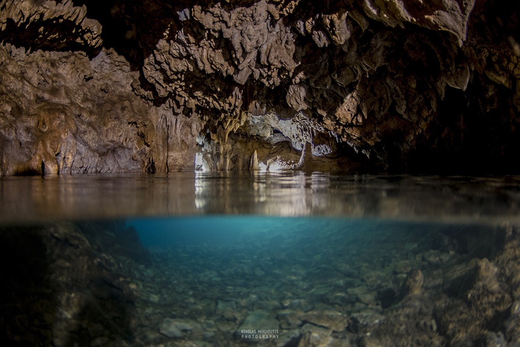
A few meters away from the village’s main square, the edge of the cave emerges through the wild vegetation. Nothing testifies to the spacious vestibule and the well-hidden secrets that exist inside. The crystal clear water gushing uninterruptedly from the depths of the underground river, wherewith the phenomenon of karst erosion the said cave has been created.
The continuous flow of water in combination with their low and constant temperature of 11 degrees Celsius is the ideal conditions for the dissolution of limestone and the formation of an extended length of underground cavities that reach 400m from the entrance cave.
Its morphology is characterized by the constant changes of its direction, which, while starting in South West (SW), ends in North West (NW).
In the first 120m of the underwater route, we find a few branches. The cave is essentially a siphon whose width along its entire length varies from 1.5m – 4m, making it impossible for divers to move in parallel.
This section finds pockets with air where the underwater visitor can emerge and admire the rich stalactite decoration of the roof just before starting the exploration for its deeper part.
Its maximum depth reaches 30m, which we meet in the last meters of the route just before entering its final ascent.
The sedimentary rocks of the cave have a substantial clay content, something that the diver perceives immediately. Diving with an open circuit shakes the clay soil on the cave’s roof so that the return is made under challenging conditions. The slightest careless movement is prohibitive as in a few seconds, the visibility can become zero with all that entails.
Research – Text editing: Andreas Andrikopoulos